The Proposed ITC Oneida–Sabine Lake 345 kV Transmission Line
An independent route and environmental analysis, route-wide and per-jurisdiction — prepared for the townships and residents of the Oneida–Sabine Lake corridor.
Revised draft · September 24, 2026
Independent Route & Environmental Analysis (41 pages)
ITC's seven published Phase-3 routes retrieved directly from its ArcGIS services, scored on the Act 30 factors with and without House Bill 5940's freeway credit, stress-tested across a million alternative weightings, and resolved township by township, with every data layer hashed and inventoried and full reproduction steps in the appendices. Supersedes the June 8 release (PDF), which used an incomplete MDOT roads layer.
Want the next one? Get new insights by email. One email per article, and nothing when we don't publish.
Video
The seven routes, explained in 14 minutes
The line, its timeline, and how Act 30 decides a route, with the source documents on screen; ITC's seven routes racing on our map; the scoring, the million-weighting stress test, and the township-by-township impacts; and what House Bill 5940 would change.

Interactive
Test the recommendation yourself
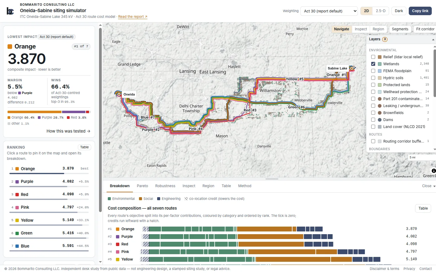
The report's cost model runs live in your browser. Move any of the Act 30 factor weights — wetlands, floodplain, residences within 500 ft, co-location with existing corridors, stream and road crossings and the rest — switch factors on or off, and watch the seven ITC routes re-rank, see where each route's cost comes from, re-run the million-weighting robustness sweep, and explore the 313,416 candidate alignments on the route graph. Every "what-if" is a shareable link. The simulator currently runs the June 8 release's model and figures; an update to the September results, including the House Bill 5940 freeway credit, is in progress.
The map draws the routes over the corridor's evidence layers — wetlands, floodplain, hydric soils, protected land, occupied residential parcels, existing transmission — on a 2.5-D relief surface built from USGS 1 m lidar.
7 routes
ITC's published Phase-3 alternatives, scored on the Act 30 factors
64%
Orange ranks first across a million weightings with HB 5940 (53% under current law)
98–0
House vote on HB 5940; no opponents listed, ITC in support
16
Communities crossed: 14 townships and 2 cities in 3 counties, each resolved separately
Executive Summary
ITC has proposed a 345 kV transmission line running roughly fifty miles from the Oneida substation in Eaton County to a new Sabine Lake substation in Livingston County, as part of MISO's Long Range Transmission Planning portfolio. For Phase-3 public comment, ITC narrowed its candidate network to seven named route alternatives — Blue, Orange, Green, Purple, Yellow, Red, and Pink.
This analysis retrieves those seven published routes directly from ITC's ArcGIS services, scores each on the factors the Michigan Public Service Commission weighs under Act 30 — environmental impact, residential proximity, and use of existing rights-of-way — ranks them, and resolves the impact township by township. It scores them twice: under current law, and with the freeway right-of-way credit House Bill 5940 would create. Every input is public and provenance-tracked; the data sources are enumerated with content hashes and the exact reproduction steps are in the appendices. It is offered as a neutral baseline that any affected party can use, and against which the applicant's eventual filing can be compared.
The bottom line
The Orange Route is the best fit among ITC's seven published alternatives, and House Bill 5940 makes the case stronger. The bill passed the House 98–0, no opponent is on record, and even ITC supports it. With its freeway credit, Orange leads Purple by 0.20 points and ranks first in 64% of a million alternative weightings, in the top three 95% of the time. Under current law Orange still ranks first, but by less than a tenth of a point (53% to Purple's 41%), and the choice turns on how heavily the Commission weighs following an existing power line against keeping the line away from homes and protected land. Where ITC's eventual preferred route differs, those trade-offs should be made explicit on the record.
Principal Findings
Finding 1
With House Bill 5940, the Orange Route is the clear best fit, and its lead more than doubles.
HB 5940 would let utilities build aboveground lines inside freeway right-of-way, after MDOT review. It passed the Michigan House 98–0 in August 2026, the House Fiscal Agency lists no opponents, ITC supports it, and MDOT is neutral; it now sits in the Senate Energy and Environment Committee. Scored on the Act 30 factors with that freeway credit, the Orange Route ranks first (3.808), well ahead of Purple (4.010) and Red (4.026). Orange runs along I-96 for about 15 miles; Purple barely touches it. If the bill does not pass, Orange still ranks first under current law, but by less than a tenth of a point (3.945 to 4.029).
Finding 2
Orange wins on what it avoids, not on length.
Orange is the longest of the seven routes (57.96 miles, about 4.2 miles more than Purple), and it is not the lowest on total environmental acreage. It ranks first because it passes the fewest selected residential parcels within 500 feet (235, against about 280 for Purple and Red and 329 for Blue) and crosses far less protected land (about 80 acres, against 172 for Purple and Red). Purple's strengths are its length and the existing 138 kV line it follows.
Finding 3
The ranking holds across a million alternative weightings.
Across one million weightings, each factor drawn from one-eighth to eight times its Act 30 value, Orange ranks first in 64% of draws with the HB 5940 freeway credit (Purple 31%), finishes in the top three 95% of the time, and ranks last in about 0.16% of draws. No single factor changes the winner unless its weight moves more than threefold from its default; the principal alternative, Purple, overtakes only when co-location with existing transmission is weighted about 3.5 times its default. Under current law the race is closer: Orange 53%, Purple 41%, with the flip at about twice the default co-location weight.
Finding 4
Every impact resolves township by township.
The seven routes cross 14 townships and two cities in Eaton, Ingham, and Livingston counties, and the analysis reports every metric per jurisdiction. The middle of the corridor is where they split: Blue, Orange, and Green run through Leroy and Handy; Purple, Yellow, Red, and Pink run through Williamstown and Locke. Two incorporated cities are easy to miss, Potterville (Blue, Purple, Red) and a detached part of the City of Lansing (Orange), and each has Act 30 notice and intervention rights.
Recommendations
- 1
Treat the ranking as a transparent, reproducible baseline for comparing ITC's seven published alternatives on the Act 30 factors, not a substitute for the Commission's weighing. Where ITC's preferred route is not the objective-preferred one, the environmental, residential, and co-location trade-offs should be made explicit on the record.
- 2
Account for HB 5940 now. With no recorded opposition and a unanimous House vote, freeway right-of-way is likely to become a siting option before the Act 30 application is filed; routes should be compared with and without it, and ITC should say whether it would redraw any route inside freeway right-of-way.
- 3
Test any preferred route against alternative weightings before relying on the ordering. The configurable objective supports re-derivation without recomputing the spatial metrics, and the appendices document how each route's standing shifts.
Research series
Permitting, power lines, and data centers
7 related analyses from Bommarito Consulting.
- 1 Open →
Michigan utility decisions · October 7, 2026
Michigan Act 30 and the MPSC
Transmission routes, rates, large loads, pipelines, and renewable siting: which law applies, who decides, and how residents can participate.
ReportVideosCase explorer
- 2 Open →
First look · September 30, 2026
The 2026 Senate Permitting Bill
Who pays, where projects go, and what states and communities can decide, with Michigan worked examples. 40-page report and a 12-minute explainer.
ReportVideo
- 3 Open →
Full reading · October 2026
BAAJA, Line by Line
What the bill actually says, what it changes in federal law, and who wins and loses, cited to page and line. 132-page report and two companion videos.
ReportVideos
- 4 Open →
Fact check · October 9, 2026
Checking the Case for BAAJA
Seventeen common claims from supporters, checked against the text: what they get right, what they leave out, and what they overstate.
PageFact check
- 5 Open →
Fine print · October 9, 2026
BAAJA's Fine Print
Changes the sponsors' summary does not describe, likely drafting errors, and one that looks hidden but is disclosed, each with a fix.
Page
- 6 You are here
Michigan case study · revised September 24, 2026
The ITC Oneida–Sabine Lake 345 kV Line
Seven published routes scored on Michigan's Act 30 factors, stress-tested across a million weightings, and resolved township by township.
ReportVideoSimulator
- 7 Open →
Michigan companion · October 2026
HB 5940: Power Lines Along Michigan's Highways
What the House-passed bill changes about lines along limited access highways, the four public bodies that still have to act, and what townships and landowners can do.
PageQ&A
Reliance and disclaimer
This document is a desk study based on publicly available data, applying standard public-domain geospatial and route-optimization methods to public regulatory datasets (ITC's own published route layers, FEMA, USFWS/USGS, Michigan EGLE, and the U.S. Census Bureau). Nothing here constitutes engineering design, professional engineering certification, legal advice, an appraisal, or a stamped siting study. Bommarito Consulting LLC prepared the June 8 release at its own expense. It prepared this revised report for the Williamstown Locke Corridor Community Alliance under guidance of counsel. The methods, weights, analysis, and conclusions are the author's, and compensation does not depend on any route, regulatory, or litigation outcome. Neither ITC, Burns & McDonnell, nor the MPSC commissioned or controlled the analysis.
Insights by email
Get new insights by email
One email when we publish something new, and nothing when we don't. No tracking pixels, and leaving takes one click.
Working on something like this? Talk to us →